Work on the project takes place as part of the program "Priority 2030" and the "Cultural Code of the Russian" of the Vyatka State University, as well as the Consortium of the Digital Archeology "Cultural Code" under the auspices of the Institute of History of Material Culture of the Russian Academy of Sciences and Sevastopol State University
How much is our city known archaeologically? Less than half of it, think the scientists of VyatSU, representing the archaeological laboratory. And if the question of studies is a matter of time, then how much of the history will the Kirov's citizens learn about and will they be able to touch it, is the question that the University decides right now.
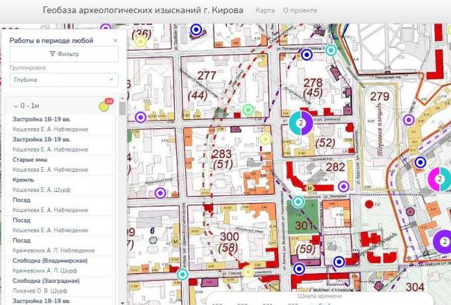
The result of the work was the unique archaeological map of Kirov. GIS-base was created by the collective of the archaeological laboratory and staff of the department of fundamental mathematics. Today, there are marked the places of archaeological works from 1935 to 2019 - supervisions, pittings, exposures. More than 150 objects. Opening the map, everyone can see who, where and when he spent archaeological work in the city. However, the database is also useful from a professional point of view. Taking advantage of the map, archaeologists, local historians will be able to guess in advance how powerful will be a cultural layer at the site of the upcoming work.
Alexey Kaisin, Head of the Archaeological Laboratory VyatSU
At the bottom of the map, we set a time marker - "Time Tape", which allows you to distribute archaeological work on the years and decades. Now objects in the database have binding on the map. There is a separation by colors denoting the power of the layer, and when you click objects, you get a brief information about the year of work and the authors of the research. There is also a satellite version of the map and a historical map with the designation of the city building from the XVII century to modern day.
In the future, the project authors are planning, the map will be complemented by new records: photos of finds and types of excavations layered on the plans of the city of different years. The location of objects will be refined and reflected in the form of polygons. In addition, archaeologists of VyatSU are actively working and creating a digital archaeological map of the Kirov region, considering open access options for this database.
You can get acquainted with the map of Kirov and its archaeological values here >>. We promise, it will be interesting!

Online newspaper
VyatSU created a unique archaeological map of Kirov
- 29 September 2021, 22:28
- Author: admin
- Views 2380